Sectional Charts
Published: DronesSectional charts are for aviators (traditional pilots, or anyone using the airspace such as drone pilots) to understand the layout of airspace. Where airports are, what type of airspace they are in, what obstructions there are, what radio frequencies they can use to communicate with Air Traffic Control, where the military might be operating, and much more! When you first look at a sectional chart, it can be quite intimidating because there are so many different colors, symbols and overlapping elements on them. Have no fear! This article walk you through having a high-level understanding of Sectional Charts and how to read them. So read on and prepare to walk away with a better understanding of sectional charts and how you can utilize them as a drone pilot, or simply to pass your Part 107 sUAS Certification exam!
What is a Sectional Chart
A sectional chart is a kind of map with a coplex overlay of information relating to aerial navigation and regulations. It tells what altitudes different classes (A, B, C, D, E, G) of airspace exist in different areas.
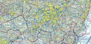
Example Sectional Chart (looks intimidating and busy, doesn't it?!):
Why does a Drone Pilot Need to Know About Sectional Charts?
If a drone pilot needs to get LAANC clearance, or know how high they can legally fly when inspecting a radio tower (for example), they can utilize these Sectional Charts to learn this information. If a drone pilot needs to know what type of airspace they are in when performing a photography, videography, or inspection job, they can utlize Sectional Charts to determine the needed information. Overall, sectional charts are extremely useful for the day to day activities of a commercial drone pilot and any aviator in general.
What are Some of the Main Elements of a Sectional Chart?
Airspace Classes
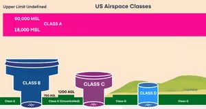
Class A
Mnemonic for class A:
- Above All (18,000 MSL to FL600 - flight level 60,000 feet in standard conditions)
Class A airspace is what we'll call "cruising altitude" for a jet-liner. Class A airspace goes from 18,000 feet MSL up to 60,000 feet MSL. All flying in Class A airspace must be conducted under IFR (Instrument Flight Rules). Class A airspace is over ALL of the United States and Alaska as well as 12 nautical miles of the coast. ATC clearance is required to be in this airspace along with a Mode C transponder with altitude reporting being mandatory. Pilots must be instrument rated and aircraft must be equipped for IFR operations.
Class B
Easy Mnemonics for this one:
- Blue lines on sectional chart
- Biggest
- Busiest
Class B airspace surrounds the nation's biggest and busiest airports. ATC clearance is required before entering this airspace. Two-way radio communications must be established and maintained in Class B airspace. It is normally depicted with blue line layers (upside down wedding cake...) around very busy airport such as LAX, ATL, or even PHL. Class B airspace is normally setup as what looks like an upside-down layered wedding cake. Wedding cakes are usually made of subsequently smaller circlular cakes that are stacked on top of each other. If you were to flip one of these over, you would get the layout of a Class B airspace.
On a section chart, class B airspace "layers" are designated with what looks like a fraction. For instance it might have the letters 70/SFC - this would indicate that this section of class B airspace extends from the Surface (the floor) up to 7000 feet (the ceiling) in the area outlined by a solid magenta line.
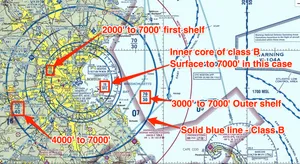
If there are two numbers that look like a fraction - 70/30 for instance - this would indicate that this Class B "shelf" has a floor of 3,000 feet and a ceiling of 7,000 feet MSL. If you entere this airspace, you need ATC clearance. HOWEVER, let's say you are flying a drone under this shelf at 350 feet AGL / 755 feet MSL, you would not need any special clearance because you are below the floor of the Class B shelf that starts at 3,000 feet elevation.
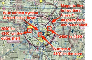
Class C
Mnemonics:
- Colored Magenta
- Core (Class C has a core and a shelf - core is Surface to 4,000' AGL for 5 mile radius - Class C's shelf starts at 1,200 feet AGL and extends up to 4,000 feet AGL)
- Communication - must establish communication with ATC before entering Class C airspace.
Class C airspace is usually surrounding moderate traffic airports. Usually consists of only two layers: 1. an Inner Core from the surface (SFC) to 4,000 feet AGL (Above Ground Level), stretching 5 nautical miles (NM) radius. The outer shelf normally starts at 1,200 feet (floor) and extends up to 4,000 feet (ceiling).
Depicted with Solid Magenta Lines.
Class D
Mnemonic for class D airspace:
- Dashed Blue on Sectional (Towered airports (blue airport symbol), Surface (SFC) to 2,500' AGL, Radio communication required before entry)
Class D are the smallest controlled airspaces, and they are not typically layered like class B or class C. You could think of class D as a cylinder extending from the surface (SFC) up to 2,500 feet AGL. So if the airport sits at 500 Mean Sea Level, the Class D airspace would extend up to 3,000 Mean Sea Level (MSL). Class D airspace typically extends on a 4-5 NM (Nautical Mile) radius from an airport. The exact distance and shape may vary based on terrain and other controlled airspace nearby.
Class D airspace is normally depicted as Dashed Blue Lines.
Class E
Mnemonic for Class E airspace:
- Everywhere else (Controlled airspace that isn't A-D, Dashed Magenta Surface, Shaded Magenta starts at 700' AGL, Shaded blue starts at 1,200' AGL, numbers on charts for higher floors, No ATC clearance needed for VFR)
Class E airspace is pretty much all controlled airspace that isn't covered by the other classes A, B, C, D or G. So wherever there is a class G airspace that ends at 1,200 feet AGL, class E would start just above that, assuming there is no other airspace directly above that section of class G airspace.
On a sectional chart, class E airspace is depicted as:
- Fuzzy Magenta (shaded side out) - Class E starting at 700 feet AGL
- Fuzzy Blue (shaded side out) - Class E starting at 1,200 feet AGL
- Dashed magenta line - Class E starting at the surface (SFC)
Class G
Menmonics:
- Ground (Uncontrolled airspace from ground up to Class E)
Class G airspace is where you will be flying a drone the majority of the time. When you're under the shelf of another controlled airspace (like class C or D, for instance) the ceiling of class G is at 700 fee AGL. When not under the shelf of a class C or D airpsace, the ceiling of Class G becomes 1,200 feet AGL. But because the "normal" maximum drone ceiling is 400 AGL, it's unlikely you'd ever get outside class G airspace. Perhaps if you were inspecting a really tall tower you might venture beyond the ceiling of class G, but it's highly unlikely.
Airport Color Meaning
Blue Airport Symbol
A blue airport depicted on a sectional chart is one that has a control tower. These airports are typically located in controlled airspace of the class B, C, or D. If the airport symbol has little tabs on it, this is telling you that the airport has services like fueling.
Magenta Airport Symbol
A burgundy airport depicted on a sectional chart is one that has not control tower. These airports are typically located in Class E or Class G (uncontrolled airspace). Magenta airfields can also have services and are depicted in the same way with tabs on either side of the circle around the airport.